
Floods Hit Myitkyina as Ayeyarwady River Rises Due to Heavy Rains in the Upper Reaches of the Mayhka and Malihka Rivers
- Pajau Media

- Jun 2, 2025
- 1 min read
Pajau Media.
June 2, 2025.


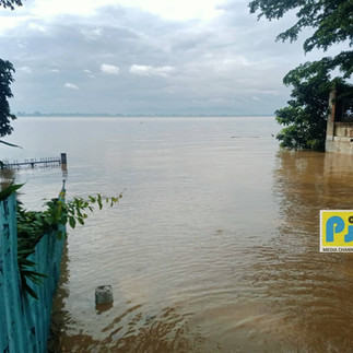


Due to heavy rainfall in the upper regions of Kachin State, the water levels of the Maykha and Malikha rivers have risen, causing the Ayeyarwady River to overflow. As a result, Myitkyina, Putao, Waingmaw, Chiphwe, and several other areas have now surpassed the danger water level.
Currently, most neighborhoods in Myitkyina city, as well as areas in Chiphwe, Sawlaw, and Mandawng, are experiencing severe flooding. This has led to displacement in IDP (internally displaced persons) camps, homes being submerged and damaged, road closures, and significant difficulties in transportation.
Moreover, according to the Kachin State Department of Meteorology and Hydrology, as of this morning, the water level of the Ayeyarwady River in Myitkyina has reached up to 5 cm above the danger mark of 1,200 cm.
Low-lying areas of Myitkyina, including Shatapru, Laykone, Kyetpaungchan, Myothitgyi, Rampu, Kyunpinthar, Kachinsu, Shwenyaungpin, Manhkring, Dukahtawng, Yangyi Aung, and Pamati, have already been flooded. Authorities have warned residents to be prepared for further rises in water levels and to take precautionary measures. Social relief organizations are also providing assistance.
According to local sources, as of around 7:30 AM today, the water level in Myitkyina reached 1,205 cm and has remained steady at that level without any significant rise or fall.
News – Hpring


Comments